


Saint Pierre Orne

pascal.dabet
User

Length
12.2 km

Max alt
261 m

Uphill gradient
241 m
Km-Effort
15.4 km

Min alt
138 m

Downhill gradient
240 m
Boucle
Yes
Creation date :
2023-04-29 13:22:23.769
Updated on :
2023-04-29 16:45:43.835
3h22
Difficulty : Difficult

FREE GPS app for hiking
 SityTrail
IGN / Geographical institutes
SityTrail Plus
The world is yours!
About
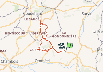
Trail Walking of 12.2 km to be discovered at Normandy, Orne, Gouffern en Auge. This trail is proposed by pascal.dabet.
Positioning
Country:
France
Region :
Normandy
Department/Province :
Orne
Municipality :
Gouffern en Auge
Location:
Saint-Pierre-la-Rivière
Start:(Dec)
Start:(UTM)
292493 ; 5410518 (31U) N.
Comments